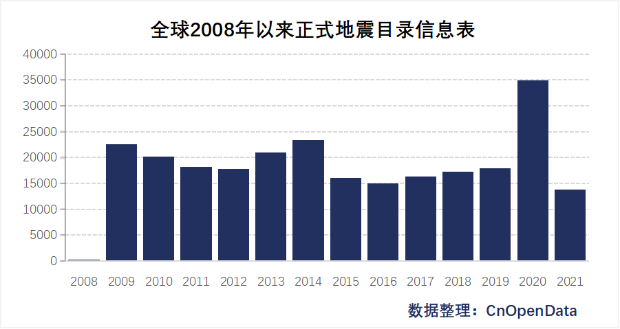
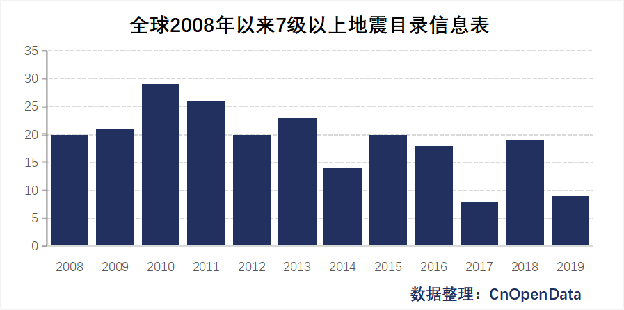
Introduction to global earthquake information data

 Earthquakes are one of the most frequent and severe natural disasters in the world. They are a major global problem facing human survival and development today. Earthquake disasters have the following outstanding characteristics:

  • Hugely destructive. Earthquakes can cause damage to mountains, the ground and their attachments (such as vegetation, buildings), etc., and are often accompanied by secondary disasters such as tsunamis, fires, landslides, and floods. They can cause a large number of casualties and property losses, and can also bring serious consequences to modern society. Economic technology will bring new disasters, such as communication accidents, computer accidents, etc.
  • Transient and unpredictable. Earthquakes occur in an instant, and their duration is very short. The minimum is ten seconds, and the maximum is two or three minutes, causing landslides and ground cracks, and houses collapsing. People cannot organize effective resistance actions in a short period of time. At present and for a long time to come, the level of science and technology is still unable to predict the arrival of earthquakes.
  • Recurrent. About 5 million earthquakes occur on the earth every year, that is, tens of thousands of earthquakes occur every day. Most of them are too small or too far away for people to feel them. There are about ten earthquakes that can really cause serious harm to humans. There have been dozens or twenty earthquakes, and there have been about one or two earthquakes that can cause particularly severe disasters.

 The impact of earthquakes on the economy and society is multifaceted. From a macro level, on the one hand, sudden natural disasters such as earthquakes can seriously damage infrastructure and buildings in the affected areas, and may cause a large number of casualties and have a negative impact on local economic development; but on the other hand, natural disasters Building damage caused by disasters provides opportunities for upgrading urban buildings and seeking new development, eliminating the contradiction between the redevelopment of land and durable buildings in urban development, and also provides new impetus for local economic development. From a micro level, the huge damage caused by natural disasters will cause local governments to face huge financial pressure in the short term in post-disaster relief and reconstruction, which may lead local governments to strengthen tax collection and administration of enterprises within their jurisdiction to obtain fiscal revenue. This is also It will have a direct impact on the enterprise.

 CnOpenData global earthquake information data includes basic earthquake information table (year, earthquake time, latitude, longitude, depth, magnitude, etc.), surrounding cities, historical earthquakes, seismic phase records, and seismic network distribution data and other informationComprehensive and complete coverage of earthquake-related information compiled by the China Seismological Network and the United States Geological Survey, providing high-quality data resources for related research.


Time interval

See each sub-table for details


Data scale

See each sub-table for details


Field display

Global historical earthquake catalog information table fields

Global official earthquake catalog information table since 2008 Global catalog information table of earthquakes with magnitude 7 or above since 2008
Earthquake year Time of earthquake
Time of earthquake (UTC+8) Longitude
Longitude (°) Latitude
Latitude (°) Depth
Depth(km) Magnitude (ms)
Magnitude Reference location
Types of earthquakes
Reference location

China Historical Earthquake Catalog Information Table Fields

China's historical earthquake catalog information table before 1969 Catalogue information table of earthquakes with magnitude 5 or above in China's history
Time of earthquake (UTC+8) moment
Longitude (°) Longitude
Latitude (°) Latitude
Depth(km) Depth
Magnitude Magnitude (ms)
Intensity Reference location
Accuracy

China Seismological Network Earthquake Detailed Information Table Fields

China Earthquake Basic Information Table List of cities surrounding the earthquake in China China Historical Earthquake Table - Within 1 Year of Current Time China Historical Earthquake Table-Occurrence time within 1 year
Index ID (cid) Index ID (cid) Index ID (cid) Index ID (cid)
Year Year Year Year
Time of earthquake (UTC+8) Time of earthquake (UTC+8) Time of earthquake (UTC+8) Time of earthquake (UTC+8)
Latitude (°) Latitude (°) Latitude (°) Latitude (°)
Longitude (°) Longitude (°) Longitude (°) Longitude (°)
Depth(km) Depth(km) Depth(km) Depth(km)
Magnitude (M) Magnitude (M) Magnitude (M) Magnitude (M)
Reference location Reference location Reference location Reference location
Surrounding cities-distance (km) Historical earthquake time (UTC+8) Historical earthquake time (UTC+8)
Surrounding cities-location Historical latitude (°) Historical latitude (°)
Surrounding cities-provinces Historical longitude (°) Historical longitude (°)
Surrounding cities - cities Historical depth (km) Historical depth (km)
Surrounding cities-regions Historical magnitude (M) Historical magnitude (M)
Surrounding cities-latitude (°) Historical location Historical location
Surrounding cities-longitude (°)

China earthquake phase information table fields

China Seismic Network Seismic Phase Table Detailed table of seismic phase records of China Seismological Network
Year of earthquake Year of earthquake
Time of earthquake (UTC+8) Time of earthquake (UTC+8)
Longitude (°) Longitude (°)
Latitude (°) Latitude (°)
Depth(km) Depth(km)
Magnitude Magnitude
Reference location Reference location
Number of earthquake phase records Number of earthquake phase records
Index ID (uuid) Station
Epicentral distance (°)
Azimuth angle (°)
Seismic phase
At that time
arrival deviation
The magnitude of the earthquake at that time
Period(s)
Amplitude (μm)
Index ID (uuid)

China Seismic Network Regional Distribution Information Table Fields

Regional distribution information table of China’s national seismic network
Province
Station name
Station code
Longitude (°)
Latitude (°)
Elevation
Type
Instruments and equipment
Taiwan network code

USGS earthquake information table fields

USGS Earthquake Information Table
year
time(UTC)
place
lon
lat
depth
mag
magType
sig
net
nst
dmin
rms
gap
title
url
status

Sample data

Global historical earthquake catalog information table - global official earthquake catalog information table since 2008

Year of earthquake Time of earthquake (UTC+8) Longitude (°) Latitude (°) Depth (km) Magnitude Types of earthquakes Reference location
2021 2021/7/31 23:51 97.7 34.76 9 1.5ML 天然地震 青海玛多
2021 2021/7/31 23:11 103.99 29.39 12 1.1ML 天然地震 四川犍为
2021 2021/7/31 23:11 98 34.75 9 1.6ML 天然地震 青海玛多
2021 2021/7/31 22:44 114.51 23.86 10 1.9ML 天然地震 广东东源
2021 2021/7/31 22:38 102.52 28.82 19 1.4ML 天然地震 四川越西
2021 2021/7/31 22:35 96.81 26.45 10 1.9ML 天然地震 缅甸
2021 2021/7/31 22:34 114.51 23.85 11 2.1ML 天然地震 广东东源
2021 2021/7/31 22:16 118.56 42.34 19 2ML 天然地震 内蒙古赤峰
2021 2021/7/31 21:29 87.9 38.25 6 1.2ML 天然地震 新疆若羌
2021 2021/7/31 20:45 97.44 34.86 9 2.1ML 天然地震 青海玛多
2021 2021/7/31 20:41 104.56 29.36 2 1.4ML 天然地震 四川荣县
2021 2021/7/31 18:33 94.71 35.98 10 1.2ML 天然地震 青海格尔木
2021 2021/7/31 18:17 95.87 34.23 10 1.6ML 天然地震 青海曲麻莱
2021 2021/7/31 17:20 111.8 23.18 11 1.4ML 天然地震 广东德庆
2021 2021/7/31 16:56 97.61 34.75 9 1ML 天然地震 青海玛多
2021 2021/7/31 16:55 97.57 34.81 9 1.2ML 天然地震 青海玛多
2021 2021/7/31 16:54 86.26 43.59 18 1ML 天然地震 新疆呼图壁
2021 2021/7/31 16:53 81.85 44.77 17 1.3ML 天然地震 新疆博乐
2021 2021/7/31 16:15 120.03 39.1 13 2.5ML 天然地震 渤海
2021 2021/7/31 16:12 105.44 29.27 5 1.1ML 天然地震 四川泸县
2021 2021/7/31 16:05 167.09 -15.02 22 4.8mb 天然地震 瓦努阿图(新赫布里底)
2021 2021/7/31 15:16 104.63 29.6 3 1.3ML 天然地震 四川威远
2021 2021/7/31 14:22 82.96 44.38 17 1.1ML 天然地震 新疆精河
2021 2021/7/31 13:26 141.91 43.42 167 4.9mB 天然地震 北海道地区
2021 2021/7/31 13:08 75.87 40.08 21 1.7ML 天然地震 新疆乌恰
2021 2021/7/31 12:09 134.76 33.58 40 4Ms 天然地震 四国岛
2021 2021/7/31 12:08 105.12 28.14 7 2ML 天然地震 四川兴文
2021 2021/7/31 12:05 101.15 32.82 8 1.8ML 天然地震 青海班玛
2021 2021/7/31 11:44 104.21 31.92 2 1ML 天然地震 四川北川
2021 2021/7/31 11:33 100.25 27.68 13 1.5ML 天然地震 云南香格里拉
2021 2021/7/31 9:58 98.83 24.44 9 1.8ML 天然地震 云南龙陵
2021 2021/7/31 9:19 105.08 28.13 9 2.5ML 天然地震 四川兴文
2021 2021/7/31 9:12 100.29 22.63 10 1.5ML 天然地震 云南澜沧
2021 2021/7/31 8:31 136.1 75.2 10 4.6Ms 天然地震 新西伯利亚群岛
2021 2021/7/31 8:10 104.9 28.36 1 1.7ML 天然地震 四川长宁
2021 2021/7/31 8:05 104.61 29.63 2 1.8ML 天然地震 四川威远
2021 2021/7/31 6:39 -173.26 -16.02 6 5.3Ms 天然地震 汤加
2021 2021/7/31 6:11 -155.05 55.46 10 5.3Ms 天然地震 阿拉斯加以南地区
2021 2021/7/31 5:10 142.52 29.51 5 4.2Ms 天然地震 本州以南地区
2021 2021/7/31 4:35 77.01 39.49 23 1.2ML 天然地震 新疆伽师
2021 2021/7/31 4:05 151.3 -7.9 5 4.8mB 天然地震 新几内亚东部地区
2021 2021/7/31 3:55 105.12 28.18 17 1.1ML 天然地震 四川兴文
2021 2021/7/31 3:47 74.87 39.63 14 1.9ML 天然地震 新疆乌恰
2021 2021/7/31 2:43 105.08 28.16 12 2.3ML 天然地震 四川兴文
2021 2021/7/31 2:31 95.56 37.67 9 1.7ML 天然地震 青海大柴旦
2021 2021/7/31 1:51 128.12 3.5 104 4.7mb 天然地震 塔劳群岛
2021 2021/7/31 1:16 116.23 46.93 19 3.6ML 天然地震 蒙古
2021 2021/7/31 1:10 -80.65 -5 30 6.3Ms 天然地震 秘鲁北部海岸近海
2021 2021/7/31 1:03 114.42 24.64 10 2.3ML 天然地震 江西全南
2021 2021/7/31 0:54 104.52 29.38 1 1.1ML 天然地震 四川荣县

Global historical earthquake catalog information table - global earthquake catalog information table of magnitude 7 or above since 2008

Time of earthquake Longitude Latitude Depth Magnitude (ms) Reference location
2008-02-08 17:38:18 -41.9 10.7 -1000 7.3 北大西洋海岭
2008-02-20 16:08:32 96 2.8 -1000 7.7 明打威海峡(明打威群岛与苏门答腊岛间)
2008-02-25 16:36:34 100 -2.4 -1000 7.6 明打威海峡(明打威群岛与苏门答腊岛间)
2008-02-26 05:02:17 99.8 -2.2 -1000 7 明打威海峡(明打威群岛与苏门答腊岛间)
2008-03-21 06:33:00 81.44 35.81 33000 7.4 新疆和田地区于田县
2008-04-09 20:46:20 168.9 -20.2 -1000 7.3 洛亚蒂群岛附近海域
2008-04-12 08:30:12 158.4 -55.6 -1000 7.1 澳大利亚北麦夸里岛附近海域
2008-05-02 09:33:36 -177.6 52 -1000 7 安德烈诺夫群岛附近海域(阿拉斯加西南阿留申群岛中部)
2008-05-08 00:45:06 141.6 36.1 -1000 7.1 日本本州茨城县附近海域
2008-05-12 14:28:04 103.4 30.95 14000 8 四川阿坝州汶川县
2008-06-14 07:43:42 140.8 39.1 -1000 7 日本本州岛岩手县
2008-06-30 14:17:51 -21.77 -58.33 26000 7 南桑威奇群岛地区
2008-07-05 10:12:05 153.1 53.9 -1000 7.6 千岛群岛西北部海域(鄂霍次克海)
2008-07-19 10:39:27 142.3 37.5 -1000 7.3 日本本州岛福岛县附近海域
2008-09-11 08:20:51 144 41.8 30000 7.1 日本北海道东南附近海域
2008-09-29 23:19:35 -177.8 -29.7 -1000 7.2 新西兰以北克马德克群岛附近海域
2008-10-19 13:10:31 -173.35 -21.32 21000 7 汤加地区
2008-11-17 01:02:32 122.1 1.3 -1000 7.1 印度尼西亚米纳哈萨以北近海
2008-11-24 17:03:02 154.4 54.1 540000 7.1 千岛群岛西北部海域(鄂霍次克海)
2008-12-09 14:24:00 -176.9 -31 -1000 7 新西兰以北克马德克群岛附近海域
2009-01-04 03:43:51 132.9 -0.4 23000 7.4 印度尼西亚伊里安岛以北海域
2009-01-04 06:33:32 133.8 -1.43 33000 7.2 印度尼西亚西巴布亚省
2009-01-16 01:49:40 154.65 47.08 36000 7.3 千岛群岛附近海域
2009-02-12 01:34:48 126.6 3.9 30000 7.2 印度尼西亚塔劳群岛附近海域
2009-02-19 05:53:46 -176.3 -27.3 33000 7.3 新西兰以北克马德克群岛附近海域
2009-03-20 02:17:37 -174.7 -23 10000 7.9 汤加地区
2009-05-28 16:24:41 -86.23 16.75 15000 7 加勒比海海岭(靠近洪都拉斯)
2009-07-15 17:22:32 166.4 -45.7 33000 7.8 新西南南岛西沿海
2009-08-04 01:59:59 -112.9 29.3 10000 7.1 墨西哥加利福尼亚湾
2009-08-09 18:56:00 138.2 33.1 320000 7.2 日本本州伊豆七岛附近海域
2009-08-11 03:55:41 92.9 14.1 33000 7.5 安达曼群岛附近海域
2009-08-16 15:38:25 99.5 -1.5 50000 7 明打威海峡(明打威群岛与苏门答腊岛间)
2009-09-02 15:55:02 107.3 -7.8 60000 7.3 爪哇南海域
2009-09-30 01:48:15 -172.2 -15.5 33000 8 大洋洲萨摩亚地区
2009-09-30 18:16:07 99.8 -0.8 60000 7.7 明打威海峡(明打威群岛与苏门答腊岛间)
2009-10-08 06:03:13 166.3 -13 33000 7.7 瓦努阿图地区
2009-10-08 06:18:24 166.3 -12.6 35000 7.9 圣克鲁斯群岛附近海域
2009-10-08 06:18:42 164.5 -13.6 33000 7.2 瓦努阿图地区
2009-10-08 16:28:45 166.1 -13.2 33000 7 瓦努阿图地区
2009-10-24 22:40:45 130.4 -6.1 140000 7.1 班达海
2009-11-09 18:44:55 178.5 -17.1 540000 7 斐济附近海域
2010-01-04 06:36:33 157.3 -8.9 33000 7.2 所罗门群岛附近海域
2010-01-13 05:53:08 -72.5 18.5 10000 7.3 海地西部省(太子港)
2010-02-27 04:31:22 128.6 25.9 33000 7.2 琉球群岛中部(冲绳诸岛附近海域)
2010-02-27 14:34:16 -72.7 -35.8 33000 8.8 智利中部沿海
2010-02-27 16:01:21 -75.58 -37.64 31000 7.3 智利中部沿海
2010-03-06 00:06:57 100.8 -4 20000 7.1 苏门答腊西南海域
2010-03-11 22:39:45 -72 -34.2 33000 7.2 智利解放者奥伊金斯将军区
2010-03-11 22:55:29 -71.8 -34.2 33000 7.1 智利解放者奥伊金斯将军区
2010-04-05 06:40:45 -115.1 32.3 33000 7.1 墨西哥北下加利福尼亚州

China Historical Earthquake Catalog Information Table-China Historical Earthquake Catalog Information Table before 1969

Time of earthquake (UTC+8) Longitude (°) Latitude (°) Depth (km) Magnitude Intensity Accuracy
1969/12/21 23:38:57 76°54" 39°54" 3.3 4 9
1969/12/20 10:09:15 110°18" 18°12" 2.4 5.2 2
1969/12/19 14:51:05 88°12" 31°12" 4 2
1969/12/17 16:00:04 110°36" 18°30" 5.1 3
1969/12/07 13:52:39 121°54" 23°42" 3.3 5.1 9
1969/12/06 24:15:70 121°54" 23°54" 3 4.7 9
1969/11/28 24:15:70 106°12" 38°06" 4 2
1969/11/24 10:01:08 99°06" 31°00" 4.6 2
1969/11/21 15:38:33 101°00" 36°42" 4.25 4
1969/11/18 52:83:30 77°00" 40°12" 4.5 3
1969/11/16 95:65:00 121°42" 24°00" 4 5.1 9
1969/11/16 10:59:22 95°30" 34°42" 4.6 5
1969/11/12 60:40:00 119°18" 15°42" 3 4.3 9
1969/11/12 60:40:00 119°24" 15°30" 3.3 4.4 9
1969/11/06 45:84:00 101°48" 32°42" 5.3 2
1969/11/05 16:09:16 76°06" 36°12" 3.8 4.6 9
1969/11/03 16:04:55 119°30" 38°12" 3.6 4 2
1969/11/03 21:19:26 120°24" 20°24" 2.3 5.1 9
1969/11/02 12:13:12 97°54" 25°24" 4 2
1969/11/01 13:52:20 121°30" 24°12" 4.8 9
1969/11/01 10:38:41 121°00" 23°12" 5.8 5 9
1969/10/30 84:75:80 121°30" 22°24" 3.6 4.7 9
1969/10/26 20:15:04 103°36" 37°18" 4.7 2
1969/10/18 18:14:40 122°18" 24°48" 7.8 5.1 9
1969/10/17 65:65:60 119°18" 38°06" 3.3 4.1 2
1969/10/17 70:20:20 101°18" 38°43" 4 1
1969/10/12 14:14:25 101°12" 20°42" 4.5 3
1969/09/29 25:32:60 73°24" 39°30" 5 3
1969/09/28 17:51:08 75°12" 38°48" 4.9 9
1969/09/27 17:51:08 102°24" 32°30" 4 2
1969/09/26 71:03:70 101°48" 32°30" 5.1 2
1969/09/26 11:01:50 102°00" 32°24" 4 2
1969/09/25 14:29:55 107°12" 38°54" 4 3
1969/09/23 15:50:53 122°12" 40°06" 4.25 3
1969/09/21 35:73:30 105°14" 33°16" 4.5 1
1969/09/20 35:30:90 104°30" 34°20" 4 1
1969/09/19 20:09:90 121°18" 22°48" 2 4.6 9
1969/09/17 34:00:90 119°36" 38°12" 3.2 4 2
1969/09/17 51:93:10 75°00" 39°42" 6.2 4.8 9
1969/09/15 22:46:23 74°48" 39°42" 3.8 5.5 9
1969/09/14 22:46:23 74°48" 39°42" 4.3 5.5 VII 9
1969/09/12 55:73:20 125°00" 35°30" 4.25 2
1969/09/05 19:42:13 121°48" 22°54" 5.8 3
1969/09/05 21:24:19 99°42" 30°24" 4 2
1969/08/28 11:58:36 73°30" 39°00" 0.9 5.6 2
1969/08/28 12:06:27 73°42" 39°00" 7.3 4.9 9
1969/08/24 16:38:00 87°12" 41°48" 4.25 2
1969/08/16 21:04:17 82°18" 41°24" 4 3
1969/08/15 15:15:38 94°42" 30°18" 4.2 9
1969/08/12 85:34:50 83°00" 32°18" 3.9 4.5 9

China's historical earthquake catalog information table - China's historical earthquake catalog information table of magnitude 5 or above

moment Longitude Latitude Depth Magnitude (ms) Reference location
2018-10-31 16:29:55 102.08 27.7 19000 5.1 四川凉山州西昌市
2018-11-04 05:36:19 77.63 40.24 22000 5.1 新疆克孜勒苏州阿图什市
2018-11-26 07:57:24 118.6 23.28 20000 6.2 台湾海峡
2018-12-16 05:21:05 121.8 23.71 26000 5.2 台湾花莲东南海域
2018-12-16 12:46:07 104.95 28.24 12000 5.7 四川宜宾市兴文县
2018-12-20 19:08:08 74.75 39.08 10000 5.2 新疆克孜勒苏州阿克陶县
2018-12-24 03:32:21 87.64 30.32 8000 5.8 西藏日喀则市谢通门县
2019-01-03 08:48:06 104.86 28.2 15000 5.3 四川宜宾市珙县
2019-01-12 12:32:02 75.59 39.57 10000 5.1 新疆喀什地区疏附县
2019-01-20 22:28:33 87.77 30.09 10000 5 西藏日喀则市谢通门县
2019-01-24 16:34:54 120.71 19.5 10000 5 南海东沙群岛东南
2019-01-30 13:21:34 122.43 23.77 20000 5.2 台湾花莲东南海域
2019-02-02 05:54:41 83.34 46.73 16000 5.2 新疆塔城地区塔城市
2019-02-16 18:01:30 125.05 25.2 10000 5 台湾赤尾屿附近
2019-03-03 03:46:19 120.4 18.62 10000 5.5 南海东沙群岛东南
2019-03-08 10:32:14 121.34 22.46 11000 5.3 台湾台东南海域
2019-03-28 05:36:31 90.89 38.28 9000 5 青海海西州茫崖行政委员会
2019-04-03 09:52:56 120.87 22.95 12000 5.7 台湾省台东县
2019-04-04 09:56:56 120.85 22.95 10000 5.3 台湾省台东县
2019-04-09 23:13:22 121.61 23.96 10000 5 台湾花莲附近海域
2019-04-18 13:01:05 121.65 24.02 24000 6.7 台湾花莲附近海域
2019-04-24 04:15:48 94.61 28.4 10000 6.3 西藏林芝市墨脱县
2019-05-18 06:24:48 124.75 45.3 10000 5.1 吉林松原市宁江区
2019-06-04 17:46:16 121.75 22.82 9000 5.8 台湾台东东北海域
2019-06-17 22:55:43 104.9 28.34 16000 6 四川宜宾市长宁县
2019-06-17 23:36:01 104.77 28.43 16000 5.1 四川宜宾市珙县
2019-06-18 07:34:33 104.89 28.37 17000 5.3 四川宜宾市长宁县
2019-06-22 22:29:56 104.77 28.43 10000 5.4 四川宜宾市珙县
2019-07-04 10:17:58 104.74 28.41 8000 5.6 四川宜宾市珙县
2019-07-12 05:21:57 122.81 23.9 7000 5.1 台湾花莲东海域
2019-07-13 08:57:41 128.26 29.15 230000 6 东海东部(琉球群岛西)
2019-07-19 17:22:14 92.89 27.67 10000 5.6 西藏山南市错那县
2019-07-23 04:46:58 124.36 25.08 130000 5 台湾钓鱼岛附近海域
2019-07-27 04:16:58 121.78 20.83 20000 5.3 菲律宾巴丹群岛附近海域(巴士海峡)
2019-07-27 07:37:59 121.96 20.8 10000 5.9 菲律宾巴丹群岛附近海域(巴士海峡)
2019-07-27 09:24:42 121.88 20.74 10000 5.5 菲律宾巴丹群岛附近海域(巴士海峡)
2019-07-27 18:11:32 121.87 20.98 4000 5 菲律宾巴丹群岛附近海域(巴士海峡)
2019-08-08 05:28:02 121.96 24.52 30000 6.4 台湾宜兰附近海域
2019-08-18 12:05:14 121.57 23.74 6000 5 台湾花莲东南海域
2019-09-05 21:58:35 116.16 14.77 20000 5.2 南海(中沙群岛)
2019-09-08 06:42:13 104.79 29.55 10000 5.4 四川内江市威远县
2019-09-16 20:48:39 100.35 38.6 11000 5 甘肃张掖市甘州区
2019-10-06 04:18:18 128.16 28.01 16000 5.1 东海东部(琉球群岛西)
2019-10-06 04:32:25 127.96 27.96 42000 5 东海东部(琉球群岛西)
2019-10-12 22:55:24 110.51 22.18 10000 5.2 广西玉林市北流市
2019-10-12 22:55:26 110.52 22.16 10000 5.1 广西玉林市北流市
2019-10-17 19:44:31 122.58 24.02 16000 5.1 台湾花莲东海域
2019-10-27 13:29:45 78.82 41.21 11000 5 新疆阿克苏地区乌什县
2019-10-28 01:56:48 102.69 35.1 10000 5.7 甘肃甘南州夏河县
2019-11-25 09:18:19 106.65 22.89 10000 5.2 广西百色市靖西市

China Seismological Network Earthquake Detailed Information Table-China Earthquake Basic Information Table

Index ID (cid) Year Time of earthquake (UTC+8) Latitude (°) Longitude (°) Depth (km) Magnitude (M) Reference location
CD20211031235152.00 2021 2021-10-31 23:51:52 39.60 118.13 5 2.3 河北唐山市路南区
CC20211030191142.00 2021 2021-10-30 19:11:41 -7.55 125.55 10 5.0 班达海
CC20211030160517.00 2021 2021-10-30 16:05:17 -19.55 -177.25 380 5.3 斐济群岛
CC20211030035526.00 2021 2021-10-30 03:55:26 -15.25 -74.20 50 5.2 秘鲁
CC20211030034225.00 2021 2021-10-30 03:42:25 -29.60 -175.75 10 5.5 新西兰克马德克群岛
CC20211030003714.00 2021 2021-10-30 00:37:14 36.13 77.72 7 3.1 新疆喀什地区叶城县
CD20211027014702.00 2021 2021-10-27 01:47:01 42.34 83.88 9 4.7 新疆阿克苏地区库车市
CC20211026134843.00 2021 2021-10-26 13:48:43 -58.30 -14.95 10 5.6 南桑威奇群岛
CD20211026113034.00 2021 2021-10-26 11:30:33 33.36 92.12 10 3.1 青海海西州唐古拉地区
CC20211026060508.00 2021 2021-10-26 06:05:08 -3.25 140.90 10 5.2 印尼巴布亚省
CC20211024131135.00 2021 2021-10-24 13:11:34 24.55 121.80 60 6.3 台湾宜兰县
CD20211023182454.00 2021 2021-10-23 18:24:54 38.15 93.79 10 3.0 青海海西州茫崖市
CD20211023111604.00 2021 2021-10-23 11:16:03 24.09 121.69 10 4.9 台湾花莲县海域
CD20211022171916.00 2021 2021-10-22 17:19:16 25.73 100.00 8 3.4 云南大理州漾濞县
CC20211021163645.00 2021 2021-10-21 16:36:45 32.00 138.60 350 5.6 日本本州东南海域
CC20211021161043.00 2021 2021-10-21 16:10:43 -25.25 -179.68 500 5.8 斐济群岛以南海域
CD20211021081223.00 2021 2021-10-21 08:12:22 43.77 84.15 11 4.2 新疆伊犁州尼勒克县
CD20211020044634.00 2021 2021-10-20 04:46:33 46.55 90.07 15 3.0 新疆阿勒泰地区青河县
CC20211019133233.00 2021 2021-10-19 13:32:32 34.65 28.25 40 5.9 地中海
CC20211018183217.00 2021 2021-10-18 18:32:16 28.54 87.41 10 3.8 西藏日喀则市定日县
CC20211018152653.00 2021 2021-10-18 15:26:53 -13.65 166.95 100 6.1 瓦努阿图群岛
CD20211018134918.00 2021 2021-10-18 13:49:17 24.22 121.76 31 4.3 台湾花莲县海域
CD20211018102057.00 2021 2021-10-18 10:20:56 29.26 103.99 8 3.2 四川乐山市犍为县
CD20211018084115.00 2021 2021-10-18 08:41:14 29.25 103.93 10 3.1 四川乐山市犍为县
CC20211018083700.00 2021 2021-10-18 08:37:00 29.26 103.96 10 4.3 四川乐山市犍为县
CC20211018055951.00 2021 2021-10-18 05:59:51 28.65 138.30 520 5.1 日本小笠原群岛地区
CD20211017054210.00 2021 2021-10-17 05:42:09 41.25 83.76 11 3.4 新疆阿克苏地区库车市
CD20211015183539.00 2021 2021-10-15 18:35:39 28.64 87.43 10 3.0 西藏日喀则市定日县
CC20211015104458.00 2021 2021-10-15 10:44:58 -8.93 158.51 10 6.3 所罗门群岛
CD20211015051004.00 2021 2021-10-15 05:10:03 44.20 120.24 10 4.7 内蒙古赤峰市阿鲁科尔沁旗
CD20211015005253.00 2021 2021-10-15 00:52:52 36.71 77.01 93 3.0 新疆喀什地区叶城县
CC20211014231629.00 2021 2021-10-14 23:16:28 1.19 126.15 10 5.4 印尼马鲁古海北部
CD20211014174959.00 2021 2021-10-14 17:49:59 39.66 92.42 8 3.9 新疆巴音郭楞州若羌县
CC20211014135158.00 2021 2021-10-14 13:51:57 -15.05 167.30 120 5.3 瓦努阿图群岛
CD20211014080421.00 2021 2021-10-14 08:04:20 33.67 91.86 10 4.1 青海海西州唐古拉地区
CC20211014050643.00 2021 2021-10-14 05:06:43 29.68 106.30 10 3.2 重庆沙坪坝区
CD20211014010956.00 2021 2021-10-14 01:09:55 41.96 83.92 12 3.1 新疆阿克苏地区库车市
CC20211013155532.00 2021 2021-10-13 15:55:31 -50.39 -72.46 10 5.5 阿根廷
CD20211013140243.00 2021 2021-10-13 14:02:42 41.91 83.40 21 4.1 新疆阿克苏地区库车市
CD20211013042418.00 2021 2021-10-13 04:24:17 30.31 94.78 10 3.0 西藏林芝市波密县
CD20211013010130.00 2021 2021-10-13 01:01:30 39.76 118.44 11 2.0 河北唐山市古冶区
CD20211012184837.00 2021 2021-10-12 18:48:36 41.17 83.49 10 3.6 新疆阿克苏地区库车市
CD20211012183718.00 2021 2021-10-12 18:37:17 40.53 123.06 5 3.2 辽宁鞍山市岫岩县
CC20211012173138.00 2021 2021-10-12 17:31:38 43.39 86.95 13 3.0 新疆乌鲁木齐市乌鲁木齐县
CC20211012172405.00 2021 2021-10-12 17:24:05 34.95 26.35 30 6.3 希腊克里特岛附近海域
CD20211012083150.00 2021 2021-10-12 08:31:50 30.34 94.83 10 3.7 西藏林芝市波密县
CC20211012071000.00 2021 2021-10-12 07:10:00 48.20 154.17 10 5.6 千岛群岛
CD20211012065129.00 2021 2021-10-12 06:51:28 39.75 118.42 13 2.3 河北唐山市古冶区
CD20211011234005.00 2021 2021-10-11 23:40:04 40.18 75.96 9 3.0 新疆克孜勒苏州阿图什市
CC20211011203436.00 2021 2021-10-11 20:34:36 0.84 126.16 30 5.4 印尼马鲁古海

Regional distribution information table of China’s seismic network

Province Station name Station code Longitude (°) Latitude (°) Elevation Type Instruments and equipment Taiwan network code
天津 青河 QHE 90.7 46.4 1321 BBVS-60 EDAS-24IP XJ
天津 沙井子 SJZ 117.3 38.6 -248 BBVS-60DBH EDAS-24GN TJ
辽宁 孤山 GUS 123.5 39.9 80 BBVS-60 EDAS-24IP LN
内蒙 鲁北 LUB 120.8 44.5 303 BBVS-60 EDAS-24IP NM
内蒙 莫尔道嘎 MDG 120.7 51.2 721 BBVS-60 EDAS-24IP NM
广西 南宁 NNS 108.1 22.8 367 CMG-3ESPC EDAS-24IP GX
山东 成武 CHW 115.8 34.9 63 FSS-3DBH(2s) EDAS-24IP SD
河北 磁县 CXT 114 36.4 320 CMG-3ESPC-60 CMG-DM24 HE
青海 西宁 XIN 101.7 36.6 2352 BBVS-60 EDAS-24IP QH
西藏 沧源 CAY 99.2 23.1 1262 BBVS-60 EDAS-24IP YN
新疆 狮泉河 SQHE 80 32.5 4403 CTS-1 EDAS-24L XZ
黑龙江 讷河 NEH 124.5 48.4 210 CMG-3ESPC EDAS-24IP HL
内蒙 海拉尔 HLR 119.7 49.2 610 BBVS-120 EDAS-24IP NM
广东 东莞 DOG 113.7 22.8 59 KS-2000(60s) TDE-324CI GD
山东 长岛 CHD 120.7 37.9 51 BBVS-60 EDAS-24IP SD
广东 龙潭口 LTK 114.6 23.6 103 CMG-3ESPC TDE-324CI GD
江苏 六合 LH 118.9 32.5 104 CMG-3ESPC CMG-DM24 JS
陕西 华阴 HUYT 110.1 34.5 800 BBVS-60 EDAS-24IP SN
山东 龙口 LOK 120.5 37.5 168 BBVS-60 EDAS-24IP SD
甘肃 青头山 QTS 97.7 39.7 2572 BBVS-60 EDAS-24IP GS
安徽 佛子岭 FZL 116.2 31.3 90 BBVS-60 EDAS-24IP AH
陕西 临潼 LINT 109.2 34.3 920 BBVS-60 EDAS-24IP SN
辽宁 沈阳 SNY 123.5 41.8 54 JCZ-1 EDAS-24IP LN
四川 成都 CD2 103.7 30.9 653 JCZ-1T EDAS-24IP SC
陕西 周至 ZOZT 108.3 34 610 BBVS-60 EDAS-24IP SN
青海 玉树 YUS 97 33 3767 CTS-1EF EDAS-24GN QH
黑龙江 嘉荫 JIY 129.8 49 150 BBVS-60 EDAS-24IP HL
山东 德州 DZH 116.3 37.4 35 FSS-3DBH(2s) EDAS-24IP SD
黑龙江 延寿 YAS 128.4 45.3 260 BBVS-60 EDAS-24IP HL
青海 曲麻莱 QML 95.8 34.1 4325 BBVS-60 EDAS-24IP QH
内蒙 包头 BTO 109.8 40.7 1305 BBVS-120 EDAS-24GN NM
青海 门源 MEY 101.4 37.4 2978 BBVS-60 EDAS-24IP QH
广东 担杆岛 DGD 114.3 22 31 KS-2000(60s) TDE-324CI GD
宁夏 同心 TXN 106.2 37.3 2553 BBVS-60 EDAS-24IP NX
天津 王匡 WAK 116.8 38.7 -247 FSS-3DBH(2S) EDAS-24GN TJ
湖北 麻城台 MCH 115.1 31.1 95 CTS-1 EDAS-24L HB
天津 高崖子 GAZ 88.5 43.5 1820 BBVS-60 EDAS-24GN XJ
四川 筠连 JLI 104.5 28.1 480 CMG-3ESPC EDAS-24IP SC
广东 中山 ZHS 113.3 22.4 50 KS-2000(60s) EDAS-24IP GD
天津 天池 TCH 88 43.8 2580 CMG-3ESPC EDAS-24IP XJ
山西 陵川 LIC 113.2 35.6 1190 BBVS-60 EDAS-24IP SX
黑龙江 塔河 TAH 124.6 52.3 460 KS-2000(120s) EDAS-24IP HL
天津 东台 DOT 117.3 38.8 -273 FSS-3DBH(2S) EDAS-24IP TJ
北京 四座楼 SZL 117.2 40.3 1063.46 BBVS-60 EDAS-24GN BU
天津 岳普湖 YPH 76.7 39.2 1189 FSS-3DBH(2s) EDAS-24IP XJ
西藏 禄劝 LUQ 102.4 25.5 1777 KS2000-60 EDAS-24IP YN
广东 湛江 ZHJ 110.3 21.3 8 BBVS-60 EDAS-24GN GD
山东 潍坊 WEF 119.1 36.7 55 FSS-3DBH(2s) EDAS-24IP SD
上海 大新中学 DAX 121.5 31.5 -375 FSS-3DBH(2s) TDE-324CI SH
云南 舟山 ZHS 122.1 30 40 BBVS-60 EDAS-24IP ZJ

USGS Earthquake Information Table

year time(UTC) place lon lat depth mag magType sig net nst dmin rms gap title url status
2021 2021/1/1 0:14 63 km N of Hatillo, Puerto Rico -66.8555 19.0631 8 3.14 md 152 pr 16 0.6482 0.52 284 M 3.1 - 63 km N of Hatillo, Puerto Rico https://earthquake.usgs.gov/earthquakes/eventpage/pr2021001029 reviewed
2021 2021/1/1 0:40 southern Mid-Atlantic Ridge -4.7622 -52.2909 10 5.3 mww 432 us 16.126 0.77 34 M 5.3 - southern Mid-Atlantic Ridge https://earthquake.usgs.gov/earthquakes/eventpage/us6000d4p7 reviewed
2021 2021/1/1 1:13 13 km NE of Yigo Village, Guam 144.9621 13.633 162.73 4.4 mb 298 us 0.1 0.74 146 M 4.4 - 13 km NE of Yigo Village, Guam https://earthquake.usgs.gov/earthquakes/eventpage/us6000d7q1 reviewed
2021 2021/1/1 1:15 9 km SSE of Maria Antonia, Puerto Rico -66.854 17.9015 12 3.01 md 140 pr 21 0.0778 0.11 225 M 3.0 - 9 km SSE of Maria Antonia, Puerto Rico https://earthquake.usgs.gov/earthquakes/eventpage/pr2021001001 reviewed
2021 2021/1/1 1:20 Kermadec Islands region -177.9341 -31.3191 10 5 mb 385 us 2.067 0.91 86 M 5.0 - Kermadec Islands region https://earthquake.usgs.gov/earthquakes/eventpage/us6000d4pp reviewed
2021 2021/1/1 1:23 19 km N of Stanton, Texas -101.7982 32.3019 5 3.1 mb_lg 148 us 0.564 0.51 41 M 3.1 - 19 km N of Stanton, Texas https://earthquake.usgs.gov/earthquakes/eventpage/us6000d4pc reviewed
2021 2021/1/1 1:31 9 km ESE of Chickasha, Oklahoma -97.8325 35.03466667 9.42 2.76 ml 125 ok 71 0 0.27 31 M 2.8 - 9 km ESE of Chickasha, Oklahoma https://earthquake.usgs.gov/earthquakes/eventpage/ok2021aada reviewed
2021 2021/1/1 1:50 28 km SSE of Farkh?r, Afghanistan 69.9285 36.324 139.79 4.1 mb 259 us 1.92 0.69 86 M 4.1 - 28 km SSE of Farkh?r, Afghanistan https://earthquake.usgs.gov/earthquakes/eventpage/us6000d4pq reviewed
2021 2021/1/1 1:50 Izu Islands, Japan region 142.0702 30.611 10 4.4 mb 298 us 3.149 0.7 128 M 4.4 - Izu Islands, Japan region https://earthquake.usgs.gov/earthquakes/eventpage/us6000d7q2 reviewed
2021 2021/1/1 2:27 17 km S of Winslow West, Arizona -110.7797 34.8795 5 2.7 ml 112 us 0.713 0.43 111 M 2.7 - 17 km S of Winslow West, Arizona https://earthquake.usgs.gov/earthquakes/eventpage/us6000d4pw reviewed
2021 2021/1/1 3:09 18 km NE of Quicacha, Peru -73.6546 -15.5297 73.56 4.4 mb 298 us 4.246 1.13 138 M 4.4 - 18 km NE of Quicacha, Peru https://earthquake.usgs.gov/earthquakes/eventpage/us6000d4q7 reviewed
2021 2021/1/1 3:20 Kermadec Islands, New Zealand -178.4847 -29.0885 226.19 4.6 mb 326 us 0.51 1.12 40 M 4.6 - Kermadec Islands, New Zealand https://earthquake.usgs.gov/earthquakes/eventpage/us6000d4qa reviewed
2021 2021/1/1 3:46 southeast of the Loyalty Islands 172.6015 -23.0784 10 4.5 mb 312 us 4.522 0.94 128 M 4.5 - southeast of the Loyalty Islands https://earthquake.usgs.gov/earthquakes/eventpage/us6000d7q3 reviewed
2021 2021/1/1 3:55 4 km N of Rododáfni, Greece 22.056 38.3055 10 4.3 mb 284 us 1.129 1.14 65 M 4.3 - 4 km N of Rododáfni, Greece https://earthquake.usgs.gov/earthquakes/eventpage/us6000d4qi reviewed
2021 2021/1/1 4:03 29 km SW of Pole Ojea, Puerto Rico -67.3803 17.785 25 2.58 md 102 pr 5 0.3497 0.12 327 M 2.6 - 29 km SW of Pole Ojea, Puerto Rico https://earthquake.usgs.gov/earthquakes/eventpage/pr2021001043 reviewed
2021 2021/1/1 4:05 171 km SSW of Tomohon, Indonesia 124.442 -0.1874 61.99 4.5 mb 312 us 1.873 1.05 45 M 4.5 - 171 km SSW of Tomohon, Indonesia https://earthquake.usgs.gov/earthquakes/eventpage/us6000d4qn reviewed
2021 2021/1/1 4:49 17 km N of Stanton, Texas -101.8087 32.2854 5 2.6 mb_lg 104 us 0.306 0.33 34 M 2.6 - 17 km N of Stanton, Texas https://earthquake.usgs.gov/earthquakes/eventpage/us6000d4qr reviewed
2021 2021/1/1 4:54 2 km SSE of P?hala, Hawaii -155.47 19.18133333 33.8 2.5 md 96 hv 55 0.1 92 M 2.5 - 2 km SSE of P?hala, Hawaii https://earthquake.usgs.gov/earthquakes/eventpage/hv72306462 reviewed
2021 2021/1/1 5:26 15 km SSW of Stanley, Idaho -114.9812 44.0808 3 3.9 mwr 235 us 0.127 0.56 55 M 3.9 - 15 km SSW of Stanley, Idaho https://earthquake.usgs.gov/earthquakes/eventpage/us6000d4qx reviewed
2021 2021/1/1 5:28 89 km ESE of Sand Point, Alaska -159.261 54.957 17.78 3.1 ml 148 us 0.227 0.54 171 M 3.1 - 89 km ESE of Sand Point, Alaska https://earthquake.usgs.gov/earthquakes/eventpage/us6000d7y8 reviewed
2021 2021/1/1 6:01 23km ENE of Thermal, CA -115.9246667 33.7446667 3.67 2.81 ml 123 ci 92 0.08022 0.18 32 M 2.8 - 23km ENE of Thermal, CA https://earthquake.usgs.gov/earthquakes/eventpage/ci39508463 reviewed
2021 2021/1/1 6:25 Kermadec Islands region -176.5878 -29.5276 10 4.5 mb 312 us 1.203 0.53 106 M 4.5 - Kermadec Islands region https://earthquake.usgs.gov/earthquakes/eventpage/us6000d7q5 reviewed
2021 2021/1/1 6:41 Kermadec Islands region -177.3427 -28.343 11.02 4.2 mb 271 us 1.035 0.7 89 M 4.2 - Kermadec Islands region https://earthquake.usgs.gov/earthquakes/eventpage/us6000d7q6 reviewed
2021 2021/1/1 7:12 65 km NE of Cruz Bay, U.S. Virgin Islands -64.3525 18.7418 32 3.5 md 188 pr 17 1.3621 0.19 340 M 3.5 - 65 km NE of Cruz Bay, U.S. Virgin Islands https://earthquake.usgs.gov/earthquakes/eventpage/pr2021001006 reviewed
2021 2021/1/1 7:45 81 km NNW of San Antonio, Puerto Rico -67.3353 19.1905 25 3.2 md 158 pr 17 0.8188 0.34 297 M 3.2 - 81 km NNW of San Antonio, Puerto Rico https://earthquake.usgs.gov/earthquakes/eventpage/pr2021001005 reviewed
2021 2021/1/1 8:08 4 km SSW of Indios, Puerto Rico -66.8393 17.9556 10 3.07 md 145 pr 21 0.0444 0.15 186 M 3.1 - 4 km SSW of Indios, Puerto Rico https://earthquake.usgs.gov/earthquakes/eventpage/pr2021001008 reviewed
2021 2021/1/1 8:24 54 km WSW of Stella, Puerto Rico -67.7316 18.1663 51 3.39 md 177 pr 12 0.589 0.55 166 M 3.4 - 54 km WSW of Stella, Puerto Rico https://earthquake.usgs.gov/earthquakes/eventpage/pr2021001007 reviewed
2021 2021/1/1 8:31 95 km SSE of Sand Point, Alaska -159.709 54.6054 23.93 2.6 ml 104 us 0.236 0.36 224 M 2.6 - 95 km SSE of Sand Point, Alaska https://earthquake.usgs.gov/earthquakes/eventpage/us6000d7ye reviewed
2021 2021/1/1 8:36 70 km SW of Nikolski, Alaska -169.4735 52.4303 35 2.8 ml 121 us 0.388 0.47 276 M 2.8 - 70 km SW of Nikolski, Alaska https://earthquake.usgs.gov/earthquakes/eventpage/us6000d4un reviewed
2021 2021/1/1 9:19 2 km WSW of Indios, Puerto Rico -66.839 17.9816 13 2.98 md 137 pr 19 0.0407 0.17 170 M 3.0 - 2 km WSW of Indios, Puerto Rico https://earthquake.usgs.gov/earthquakes/eventpage/pr2021001010 reviewed
2021 2021/1/1 9:25 5 km WSW of La Parguera, Puerto Rico -67.092 17.9475 10 3.33 md 171 pr 20 0.0526 0.18 236 M 3.3 - 5 km WSW of La Parguera, Puerto Rico https://earthquake.usgs.gov/earthquakes/eventpage/pr2021001013 reviewed
2021 2021/1/1 9:26 Mariana Islands region 143.417 21.6209 269.45 4 mb 246 us 5.565 0.62 70 M 4.0 - Mariana Islands region https://earthquake.usgs.gov/earthquakes/eventpage/us6000d7q9 reviewed
2021 2021/1/1 10:04 Kermadec Islands region -177.1883 -31.0417 10.72 4.5 mb 312 us 1.902 0.34 150 M 4.5 - Kermadec Islands region https://earthquake.usgs.gov/earthquakes/eventpage/us6000d7qa reviewed
2021 2021/1/1 10:18 56 km ESE of Boca de Yuma, Dominican Republic -68.1413 18.1405 163 3.86 md 229 pr 16 0.4439 0.38 176 M 3.9 - 56 km ESE of Boca de Yuma, Dominican Republic https://earthquake.usgs.gov/earthquakes/eventpage/pr2021001009 reviewed
2021 2021/1/1 10:26 3 km SSE of Magas Arriba, Puerto Rico -66.7521 17.9866 13 2.99 md 138 pr 14 0.1941 0.19 171 M 3.0 - 3 km SSE of Magas Arriba, Puerto Rico https://earthquake.usgs.gov/earthquakes/eventpage/pr2021001015 reviewed
2021 2021/1/1 10:57 1 km S of Guánica, Puerto Rico -66.908 17.9591 9 3.51 md 192 pr 19 0.1366 0.13 186 M 3.5 - 1 km S of Guánica, Puerto Rico https://earthquake.usgs.gov/earthquakes/eventpage/pr2021001011 reviewed
2021 2021/1/1 11:12 58 km NW of Ivanof Bay, Alaska -160.0219 56.3296 119.4 2.6 ml 104 ak 0.44 M 2.6 - 58 km NW of Ivanof Bay, Alaska https://earthquake.usgs.gov/earthquakes/eventpage/ak0211u5q1u reviewed
2021 2021/1/1 11:55 204 km WSW of Adak, Alaska -179.5022 51.4473 35 4.1 mb 259 us 1.808 0.66 211 M 4.1 - 204 km WSW of Adak, Alaska https://earthquake.usgs.gov/earthquakes/eventpage/us6000d7qq reviewed
2021 2021/1/1 12:10 13km SE of Mammoth Lakes, CA -118.8736667 37.5533333 6.54 2.72 md 114 nc 36 0.05094 0.03 55 M 2.7 - 13km SE of Mammoth Lakes, CA https://earthquake.usgs.gov/earthquakes/eventpage/nc73505505 reviewed
2021 2021/1/1 12:15 107 km SSE of Sand Point, Alaska -159.7735 54.4626 19.31 2.6 ml 104 us 0.384 0.35 279 M 2.6 - 107 km SSE of Sand Point, Alaska https://earthquake.usgs.gov/earthquakes/eventpage/us6000d7yi reviewed
2021 2021/1/1 12:21 18 km SSW of Falls City, Texas -98.1177 28.8387 5 2.7 mb_lg 112 us 0.161 0.54 85 M 2.7 - 18 km SSW of Falls City, Texas https://earthquake.usgs.gov/earthquakes/eventpage/us6000d4su reviewed
2021 2021/1/1 12:43 100 km SSE of Sand Point, Alaska -159.8189 54.5264 10 2.7 ml 112 us 0.333 0.3 253 M 2.7 - 100 km SSE of Sand Point, Alaska https://earthquake.usgs.gov/earthquakes/eventpage/us6000d7y9 reviewed
2021 2021/1/1 12:47 101 km SSE of Sand Point, Alaska -159.8721 54.5033 10 2.5 ml 96 us 0.367 0.17 263 M 2.5 - 101 km SSE of Sand Point, Alaska https://earthquake.usgs.gov/earthquakes/eventpage/us6000d7yk reviewed
2021 2021/1/1 13:35 7 km SSE of Edgerton, Wyoming -106.225 43.3502 14.33 2.5 ml 96 us 0.732 0.7 134 M 2.5 - 7 km SSE of Edgerton, Wyoming https://earthquake.usgs.gov/earthquakes/eventpage/us6000d4t0 reviewed
2021 2021/1/1 13:42 17 km N of Stanton, Texas -101.7862 32.2906 5 3.4 mb_lg 180 us 0.311 0.52 57 M 3.4 - 17 km N of Stanton, Texas https://earthquake.usgs.gov/earthquakes/eventpage/us6000d4t2 reviewed
2021 2021/1/1 14:57 134 km SSE of Perryville, Alaska -157.9501 54.9073 25.6 2.9 ml 129 ak 0.35 M 2.9 - 134 km SSE of Perryville, Alaska https://earthquake.usgs.gov/earthquakes/eventpage/ak0211w7pul reviewed
2021 2021/1/1 15:53 1 km S of Guánica, Puerto Rico -66.9096 17.9548 11 2.98 md 137 pr 13 0.1354 0.13 204 M 3.0 - 1 km S of Guánica, Puerto Rico https://earthquake.usgs.gov/earthquakes/eventpage/pr2021001018 reviewed
2021 2021/1/1 15:58 13km NE of Coso Junction, CA -117.8431667 36.1305 2.65 2.71 ml 113 ci 39 0.016 0.17 53 M 2.7 - 13km NE of Coso Junction, CA https://earthquake.usgs.gov/earthquakes/eventpage/ci39508687 reviewed
2021 2021/1/1 16:03 1 km ENE of Magas Arriba, Puerto Rico -66.755 18.024 13 2.8 md 121 pr 15 0.1499 0.15 138 M 2.8 - 1 km ENE of Magas Arriba, Puerto Rico https://earthquake.usgs.gov/earthquakes/eventpage/pr2021001019 reviewed
2021 2021/1/1 16:36 31 km SSW of Lárdos, Greece 27.9122 35.8225 77.23 4.1 mb 259 us 0.425 1.2 123 M 4.1 - 31 km SSW of Lárdos, Greece https://earthquake.usgs.gov/earthquakes/eventpage/us6000d4tp reviewed

Data update frequency

Annual Update

文件下载